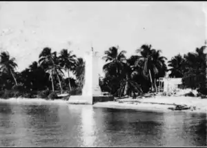
 Puerto Morelos is a town and seaport in Quintana Roo, Mexico’s easternmost state, on the Yucatan Peninsula. The town is located in the northeast of the state, about 36 km south of the resort city of Cancun, and about 30 km north of the city of Playa del Carmen. It has historically been the main port between the mainland of Yucatan and the Island of Cozumel, and an automobile ferry used to run from Puerto Morelos to Cozumel. The town is named after Independence leader Jose Maria Morelos. In 1929, Puerto Morelos was a town largely consisting of wooden homes, a lighthouse, a harbor, and one only street located parallel to the coast, and a warehouse (please remember this warehouse as it is an important part of our story). In September 1967, a powerful hurricane named Beula tilt the town lighthouse. This lighthouse already resisted two hurricanes before in the year 1955 and later on would surive two category 5 hurricane, Gilbert in 1988 and Wilma in 2005. This old strong lighthouse is now the flagship of Puerto Morelos.
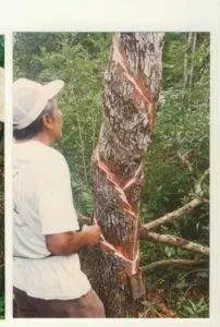
In the 60’s, some hardwoods were extracted (such as Chechen) to be sold to the federal government, the profits were going to be used for building and maintenance of the railways. Puerto Morelos was significant for both the gum and coconut oil industries. Sadly, the gum Industry faced a drastic reduction at the beginning of the 80’s due to two factors, the introduction of synthetics substitutes in the global market, and unforeseen natural catastrophes such as wildfires, and hurricanes. And the coconut oil industry came under attack in favor of healthier oils (as believed at the time) such as corn and vegetable. It was like this how Puerto Morelos became (until 2002) the main supply and storing center for Cozumel Island.
One hundred meters off shore lies the Puerto Morelos portion of the Mesoamerican Barrier Reef System, designated as a National Marine Park in 1998 due to local environmental activists. Resorts are abundant in the Puerto Morelos region along the Riviera Maya and attractions, such as the Crococun Crocodile Zoo, the Botanical Garden, and a host of cenotes are also increasing in number. Recently new smaller inns have been built which offers an evening programs of Talks on local history, marine biology, and healthy living practices.
 Today, Puerto Morelos coasts are home of all kinds of restaurants and handicraft stores, of development and promotion of tourism activities, of ways to encourage Mexicans traditional culture, of creation and care of natural areas, and a large etcetera. From their docks the second biggest coral reef can be accessed, it can also be accessed to old archaeological Mayan zones, to La ruta de los cenotes, to various farms and to an infinite number of cultural activities.
Not too long ago, in January 6 th 2016, Puerto Morelos finally was able to fulfill and old dream of their habitants, it finally acquired his own township. Puerto Morelos merged with the village of Leona Vicario on December 6, 2015, to become the 11th municipality in Quintana Roo, separating from its former municipality of Benito Juarez.
Puerto Morelos is divided by a highway and a mangrove swamp into three sections. The section west of the highway is known as “Colonia Joaquin Zetina Gazca”. The section east of the highway is called “Colonia Pescadores”. The section on the coast east of the mangrove swamp is “Puerto” or “Antiguo (old) Puerto Morelos”. This original coastal fishing village is now a quiet, mixed-use neighborhood of private homes, hotels, condominiums, restaurants, and tourist shops. The second part is about 2 km. inland and adjacent to Highway 307, on the western side. The inland portion is mainly single level dwellings for local workers. New residential developments have sprung up in recent years adding to the housing mix. There are now multi-story apartment buildings, and private residential developments between the highway and the mangrove where one can buy lots and build a house of one’s own design.
